

Library — 1802
Bowles's two-sheet plan of the cities of London & Westminster
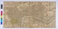
A plan of London, titled ‘Bowlers’s two-sheet plan of the Cities of London and Westminster, with the Borough of Southwark: comprehending the New Buildings and other Alterations, 1802’, published by Bowles and Carver in No. 69, St. Paul’s Churchyard, London. Fifth edition (1st edition published in 1796). Folding map, in colour, mounted on linen. Extent: Islington, Ratcliff, Newington Butts and Brompton. Includes list of parishes, great offices of state, scale and advertisement for other publications.
- Category:
- Library
- Object ID:
- A13021
- Object name:
- Bowles's two-sheet plan of the cities of London & Westminster
- Object type:
- Artist/Maker:
- Bowles and Carver
- Related people:
- Related events:
- Related places:
- Production date:
- 1802
- Material:
paper, ink, linen
- Measurements/duration:
- H 470 mm, W 943 mm (overall)
- Part of:
- —
- On display:
- —
- Record quality:
- 60%
- Part of this object:
- —
- Owner Status & Credit:
Permanent collection
- Copyright holder:
digital image © London Museum
- Image credit:
- —
- Creative commons usage:
- CC BY-NC 4.0
- License this image:
To license this image for commercial use, please contact the London Museum Picture Library.
Download image file
You are welcome to download and use this image for free under Creative Commons Licence CC BY-NC 4.0.
Credit: London Museum
To licence this image for commercial use please contact the London Museum Picture Library